|
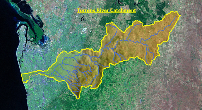
Flood Catchment Graphic
This graphic is
included as sample of a river catchment showing the Torrens River from it’s
headwaters east of Mount Pleasant in the Adelaide Hills to the point of
outflow to the sea at Henley Beach South (since 1939). It illustrates the characteristics
of a catchment being region of land where water from rain or snowmelt
drains downhill into a body of water, such as a river, lake, estuary,
wetland, sea or ocean. The river catchment includes both the streams and
rivers that convey the water as well as the land surfaces from which water
drains into those channels.
The river catchment
acts like a funnel - collecting all the water within the area covered by
the basin and channeling it into a waterway. Each river catchment is
separated topographically from adjacent basins by a ridge, hill or
mountain, which is known as a water divide or sometimes a watershed (in
those parts of the world where the river catchment itself is not called a
watershed).”
If you have Google
Earth installed on the computer, click on the picture above to see a
satellite image of the catchment.
In addition to river
catchment the following terms can be used to describe the same concept:
-
catchment, catchment area, or catchment basin
- drainage area
- river basin
- water basin
The two key defining
characteristics of a drainage basin is the drainage divide that traces the
perimeter of the basin, and the river or drainage network that conveys the
surface water out of the basin. The two are closely related. Over
geological time, outward movement of the divide would generally force the
river network to expand as well, and growth of the river network generally
forces the drainage divide to shift outward.
The shape of a
drainage basin is determined by tectonics and geomorphic processes.
Mountain ranges are natural drainage divides — the River Murray is bounded
on the west by the Great Dividing Range; the Onkaparinga is bounded on the
north by the watershed boundary near Mt Torrens and on the east by the Mt
Lofty Ranges. The shape of smaller basins is determined by erosion, and by
those environmental factors that control erosion, such as the dip of any
underlying geological feature.
Sediment eroded from
a drainage basin is conveyed to the outlet, along with the water that
transports it, along the glaciers, streams and rivers that comprise the
drainage network. Over geologic time, this network changes. For example,
gullies eroding into a hillside may erode so far as to lower the ridge or
peak at the top of the hill. As this happens the position of the drainage
divide shifts in the direction of the gully growth, and the drainage basin
expands. If a river network erodes so much, it may start to drain
pre-existing rivers by a process called stream capture. Because erosion
tends to lead to the expansion of the river network, and hence of the
drainage basin as well, adjacent drainage basins are in a way competing for
land area. The drainage divide between the two becomes essentially fixed
once the rate of erosion on one side of the divide equals the rate of
erosion on the other. Therefore, as the intervening ridge erodes away, it
simply lowers its elevation (unlike when a gully erodes it from just one
side).
On the other hand a
river channel can be cut off by rising of the land. Geologists have
identified an old channel where the River Murray used to run to the west,
which has now been cut off by the Mt Lofty ranges.
Much of this material is supplied courtesy of the
online encyclopedia the Wikipedia
|
